
Length: 0.8 Miles
Difficulty: Easy to Medium
Driving Instructions
From Alamosa, drive US 160 East for 15 miles and see the signs for Great Sand Dunes National Park. Take a left turn and drive north for 10.5 miles on Colorado 150. The sign and road for Zapata Falls will be on your right. The road is a rough gravel surface and steep for 3 miles to the parking lot. Passenger cars are fine, as there is no problem with clearance. It is a ‘vehicle shaker’ with lots of bumps in the road, so plan on extra time and slow speeds. However, it is well worth the trip.
Trailhead Parking
This is a free hike and parking lot. Parking is limited and can be busy on weekends and afternoons. Overflow parking is available on the road. Pets on leash allowed.
Elevations
9,000 to 9200 feet.
Description
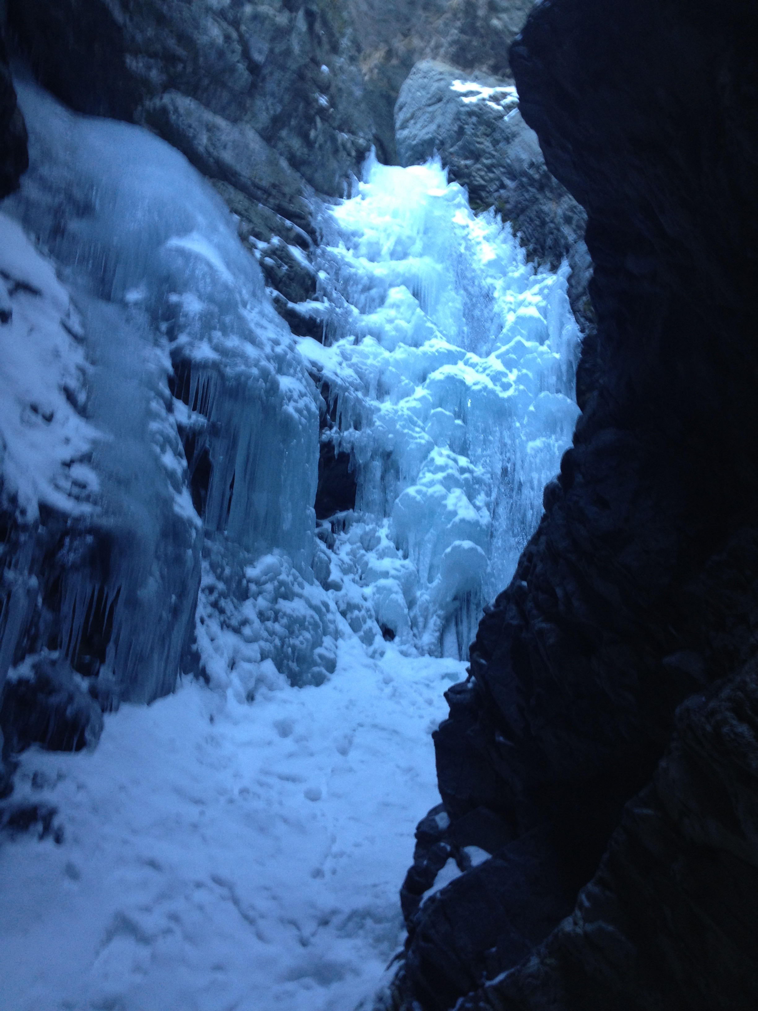
Zapata Falls is a 25 foot waterfall tucked away inside a cave. The parking lot is a thousand feet off the valley floor and offers full views of the San Luis Valley and a great view North to the Great Sand Dunes National Park and the high mountains above them in the Sangre de Cristo Range. The hike to get there is an easy stroll on a gravel trail, through a variety of tree species. To get into the cave requires walking through the creek. WEAR SHOES THAT CAN GET WET. The water is snowmelt and is cold. Though perhaps sunny and warm outside the cave, it can be quite cool near the falls, as the cave is out of the reach of the sun.
Terrain
Rocky trail with high desert vegetation mixed with forest especially near the creek. Hiking on wet rocks in the creek the last 75 yards to see the falls is required and can be difficult footing at times, especially during spring runoff or heavy rain during summer thunderstorms.
Water/Bathrooms
Bathrooms are available at the parking lot. Water along trail with proper filter or treatments.
Pleasures and Perils
This is a unique geologic wonder of how mountain stream water has for thousands of years carved a deep vertical gorge to reach the valley floor. It combines a waterfall, caving, great mountain and valley views with Sand Dunes in the near distance. Footing in the creek to reach the falls can be slippery and difficult to negotiate for some people. Water is cold and can cause cold feet and hypothermia. Have dry clothes and additional dry socks and shoes in your vehicle. Occasionally, the road may require 4 wheel drive in deep snow but the road faces west and usually dries out in several days.
Significance
Zebulon Pike and his exploring team camped near South Zapata Creek where it flows into the San Luis Valley in January 1807. The waterfall is a geologic wonder. The water from the creek never joins another stream as it disappears underground when it reaches the valley.
Notes
This short hike can be combined with the South Zapata Lake Trail, which is a nearly 10 mile round trip steep trail. Prepare accordingly as this is a day long hike. There is also a campground near the trailhead.
SHARE YOUR PHOTOS USING #VISITALAMOSA


